


les allues - col de la lune

Bogapuki
User
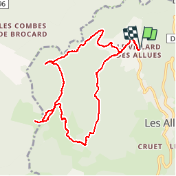

Length
10.5 km

Max alt
1793 m

Uphill gradient
590 m
Km-Effort
18.4 km

Min alt
1211 m

Downhill gradient
593 m
Boucle
Yes
Creation date :
2018-11-25 09:19:22.25
Updated on :
2018-11-25 09:19:22.25
3h45
Difficulty : Easy

FREE GPS app for hiking
 SityTrail
IGN / Geographical institutes
SityTrail Plus
The world is yours!
About
Trail Walking of 10.5 km to be discovered at Auvergne-Rhône-Alpes, Savoy, Les Allues. This trail is proposed by Bogapuki.
Positioning
Country:
France
Region :
Auvergne-Rhône-Alpes
Department/Province :
Savoy
Municipality :
Les Allues
Location:
Unknown
Start:(Dec)
Start:(UTM)
308345 ; 5035170 (32T) N.
Comments